I-44 trunk relocation near Tulsa east interchange
ODOT MOT and night windows — permit lead exceeds bore duration.
Tulsa, OK · Tulsa County
Tulsa highway, rail, and Arkansas River crossings on I-44 and US-75 — long-span HDD when open cut fails ODOT, floodplain, and BNSF review.
River, highway, and railroad crossings in Tulsa are default trenchless territory — ODOT District 1 on I-44 and US-75, BNSF through the east industrial belt, and Arkansas River floodplain paths rarely clear as open cut against engineered bore plans.
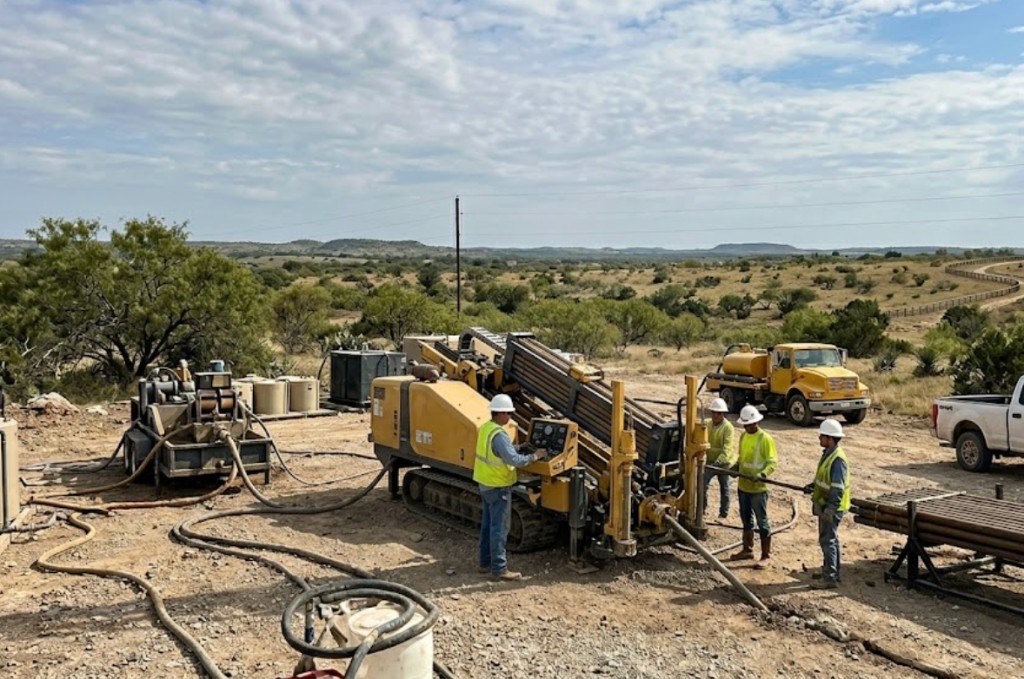
Directional boring in Tulsa at crossing scale means larger spreads, staged reaming, and agency calendars starting months before drill day. Creek Turnpike Authority and river environmental windows often set schedule more than rig availability.
Municipal trunks, telecom backbones, and PSO feeders share casing and MOT complexity — multiple utilities in one shell need engineered dividers, not improvised bundling. Survey as-builts and inspection holds follow owner agreements.
Real Tulsa County angles — not generic statewide copy.
ODOT MOT and night windows — permit lead exceeds bore duration.
Floodplain and bank stability — HDD avoids open cut through wet alluvium and trail systems.
Railroad template, flagging, welded inspection — method per agreement.
Turnpike permits and franchise — long shot with staged ream and survey closeout.
Tulsa crossing work identifies controlling permit first — ODOT, turnpike, railroad, or floodplain leads beyond 811. Larger rigs with mud plants and pullback monitoring; inspection per agency documents. As-built survey before final restoration.
Tulsa County mixes sandstone, siltstone, and claystone with sandy Arkansas River alluvium — variable bearing and groundwater along the river corridor.
Tulsa bores encounter Pennsylvanian sandstone and shale east and south of downtown, with softer alluvium and sand in Arkansas River bottoms. River-adjacent shots risk frac-out into the water table without proper mud weight. West toward Sand Springs and Sapulpa, claystone dominates with intermittent rock lenses that slow penetration without correct tooling. We pull geotech when city records are thin — especially on floodplain and levee approaches.
Arkansas River humidity, spring tornado season, and summer heat shape Tulsa bore schedules — lightning holds and post-storm saturated banks are planned into quotes.
Spring tornado season and Arkansas River flood stages are Tulsa's biggest calendar variables. Saturated river banks delay entry work; lightning shuts down rigs during severe weather. Summer humidity affects crew safety and fluid performance on long pulls along the IDL. We schedule around known wet seasons instead of forcing bores into unstable banks.
City of Tulsa Engineering Services, Tulsa County ROW, ODOT District 1, Arkansas River floodplain, and Creek Turnpike Authority permits appear on many metro bores.
City of Tulsa permits govern street cuts, drive removals, and floodplain work along the Arkansas River. Tulsa County handles ROW outside city limits toward Broken Arrow and Owasso. ODOT District 1 controls I-44 and US-75 state bores — MOT and night windows are common. Creek Turnpike Authority adds a layer on turnpike frontage. Railroad agreements on BNSF lines through the industrial corridor require separate timelines from 811.
Major Tulsa crossings rarely justify open cut — detour, floodplain, and lane math favor trenchless after alignment approval.
Length, diameter, groundwater, environmental windows, flagging, engineering, inspection.
You share plans or describe the problem; we confirm alignment, depth, access, and which trenchless method fits Oklahoma soils.
Oklahoma One-Call ticket filed; two business days minimum before pits open unless your permit path differs. We pothole where marks conflict.
Bore plan, ODOT or city ROW permits, railroad agreements, and crossing engineering when the path leaves private property.
Compact spread for tight Edmond lots; larger HDD for I-35 or I-40 relocations — matched to length and diameter.
Steered pilot on design line, ream passes sized for your pipe or casing, fluid program tuned for clay or sand lenses.
HDPE fusion, steel casing, or multi-duct bundle pulled with tension and bend-radius monitoring.
Pressure test, mandrel, or survey records for owners, inspectors, and operators as spec requires.
Compact pits, replace sod or hardscape per scope, leave 811 ticket and locate map in your project file.
District 1 scope drives weeks-to-months — permits before drill date.
With engineered dividers and maintenance access per owner — not ad hoc bundling.
Arkansas River and tributaries carry floodplain and bank rules distinct from upland bores.
Yes — BNSF templates with flagging; railroad agreements often critical path.
Length, diameter, groundwater, MOT, environmental windows, inspection — engineered quotes only.
24/7 — Emergency dispatch statewide. Tell us entry, exit, pipe size, and county — a bore specialist calls back with cost drivers, not a flat rate.
Scope your bore path
Step 1 of 2 — path, pipe, and city first